
Circular hike - tourist highlights in Willingen
Course: Kurpark, Ettelsberg, Mühlenkopfschanze, Skywalk, Strycktal, town centre (2 variants): Length approx.5.5/6.5 km - walking time approx. 2-2.5 hours
A wonderful walking tour to explore the village and nature around Willingen.
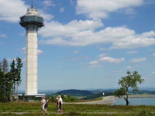
The hike starts at the Kurpark to the valley station of the cable car with which we reach the Ettelsberg (free of charge with MeineCardPlus From Ettelsberg summit the hiking route is also suitable for well-suspensed strollers. The Hochheideturm is the highest viewpoint of the Sauerland and the whole of northwest Germany (875m above sea level). From here you have a magnificent view over the Sauerland, north Hesse. Bergland - and with a good view to the Teutoburg Forest. Rarely even the resin/brocken with binoculars is visible in clear inversion weather conditions. Then the actual hike begins:
Variant 1 leads around the back through the hiking area Ettelsberg to Mühlenkopfschanze and Skywalk: You pass the tower and mountain lake on your right in the direction of Clemesberg/Hochheide Hoher Hagen; after about 400 meters you reach the Kyrill path (a lot of fun climbing!). Then you continue to the Großer Grube, a hiking area with shelter. Here we turn left towards Mühlenkopfschanze (signposted). After approx. 1.5 km we reach the inrun tower of the largest large hill in the world. (for 2€ you can enter the Adlerhorst by lift to share the view into dizzying depths with the ski jumpers). Afterwards, you can test your nerves at dizzying altitude during a tripp over the 669m long Skywalk.
Now there are two options:
- either the 1km shorter and more convenient way with the funicular (free of charge with MeineCardPlus ) down to the ski stadium and then on to the Romantikhotel Stryckhaus.
- does not use the funicular railway but follows the forest path further slightly downhill through the forest. After the strong right turn, you go left into the forest educational trail (not good for strollers – alternatively follow the forest path to the Romantikhotel Stryckhaus, where the path passes through the forest educational trail again, the pram route is 300m shorter than through the forest educational trail). At the end of the forest trail you reach a forest path, where you turn sharp to the right and run slightly downhill to the Romantikhotel Stryckhaus. (Way from Ettelsberg 3.6km through the forest trail and 2.6km by funicular)
Variant 2 leads us around the Ettelsberg with a magnificent panorama over Willingen and the nature park Diemelsee.
We walk left past Siggis hut and then right direction along a path through the Hochheide. This leads us around the Ettelsberg around the forest path "At Tiasbusch" past the new K1 chairlift track. On the whole length of the trail we enjoy a great panoramic panorama over all Willingen and a great view over the nature park Diemelsee. The path leads us then under the cable car route through to the upper Wilddieblift and above the Wild- und Freizeitpark pass always further to the Romantikhotel-Stryckhaus. Here there is the option of running from the Stryckhaus still 2x500m back to the Mühlenkopfschanze and to the Skywalk (see variant 1).
(Variant 2 route from Ettelsberg to Stryckhaus 2.5km)
At the Romatikhotel-Stryckhaus both variants of Ettelsberg meet again. In the Stryckhaus you can take a nice break, alternative refreshments are the "Café Aufwind" at the Mühlenkopfschanze or the "Old Forest House in Stryck", which is reached by continuing the hike 300m and the road from the Romantikhotel StryckHaus further down the valley. You get to the bridge over the Itterbach, where you find the Old Forest House and also a children's playground. From here you follow the Hiking trail to Willingen along the Itterbach through the Strycktal and Stryckpark (with water tread), past the Kurpavillion towards the railway viaduct, where the adventure golf course is located (free of charge with MeineCardPlus Continue towards the town centre through Willingen's main shop street. Opposite Göbels Landhotel we turn left a narrow path into the spa park where our hike ends. To the finale there is also a Kneipptret basin and you can visit the gallery of Upländer artists in the Kurpavillion. (Way from Stryckhaus to Kurpark 3km)
Have fun exploring nature and tourist highlights around Willingen!
Google Maps Route history Variant 1:
Google Maps Route description Variant 2:
Show more
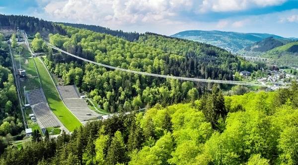
Skywalk Willingen - the second longest suspension bridge in the world!
The top leisure and excursion sensation - opening July 2023! The Sauerland is richer around a top attraction. Since 2023 in Willingen stands the second longest free-floating pedestrian suspension bridge in the world in Tibetan style with 669m length and 100m height in the middle. It is located in direct vicinity to Mühlenkopfschanze - the largest large hill in the world. A tripp over the Skywalk is not for weak nerves, because the slightly wobbly bridge with transparent grid floor provides adrenaline runs. In combination with the Mühlenkopfschanze and Germany's largest New Hagen, Germany as well as the Ettelsberg with cable car and Hochheideturm (highest viewing point in North-West Germany at 875m above sea level) Willingen has sights and nature experiences with a supra-regional character, which makes the already very popular holiday resort an absolute visitor magnet for Sauerland holidaymakers and day guests. A day in Willingen with its numerous super attractions is now part of the program! More information and online tickets: www.skywalk-willingen.deShow more
Kahler Asten-Steig - Dream tour in the Sauerland
A treat for hiking enthusiasts!
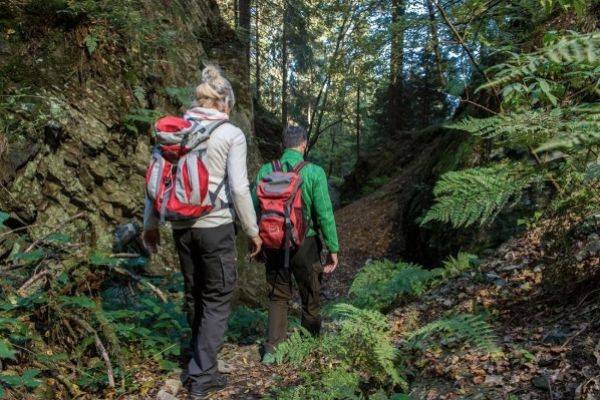
Who committed it usually says that the bald Asten-Steig the most beautiful day hiking tour in Sauerland is. It is a premium hiking trail - and beyond Dream Tour 2017 certified by the German Hiking Association.
Start and finish point of the 16 km long medium-sized circular trailit is the park of Westfeld, one of the nine federal gold villages in Schmallenberg's Sauerland. First, we take a narrow path uphill to the Grillplatz and then continue along the valley hiking trail to Ohlenbach. Now the trail leads into the valley of Schwarzen-Siep, a nature reserve with the new climbing bridge that spans a small biotope. Then it goes slightly uphill through a Kyrill area and over a Pirschpath to the hunting lodges.
An old hollow path leads us now steeply up the mountain through a small gorge, past a small quarry, to the peak of the hike, the Asten Plateau with high heat and fantastic views into the land of the 1000 mountains. The Astenhaus offers itself for a stop before it goes downhill again past the Lennequelle into the young Lennetal.
Half way up, the path branches off behind the fish ponds towards Hoher Bone. Through high spruce and beech forests, it goes towards the bone tip. Arriving at the top, we again have a wonderful view over the expanses of Schmallenberg Sauerland.
From here, you will pass a narrow path and a forest path downhill to the Hotel Hoher Knechen with St. Elisbeth Chapel and Kneipp Basin further back towards Westfeld, where you will pass a narrow root path, past the cross-country skiing centre back to the Westfelder Park, where you can end a dreamlike hiking day.
The Astensteig is a challenging hiking trail and with its 570 altitude meters demands quite condition. Lowest point is 493m, highest point is at 841m. Pure walking time approx. 5-6 hours.
Hiking map with altitude profile for download as Pdf
Show more

Great Sauerland tour to Biggesee including Attahöhle
Willingen - Winterberg - Schmallenberg - Lennetal - Attahöhle - Biggesee - Olpe - Eslohe - Hennesee/Meschede - Ruhrtal - Olsberg - Willingen You can also start this tour in any other place on the tour. This day tour is a beautiful Sauerland tour. Experience great views and many sights of the Sauerland on this tour. In order to have enough time for stops in between, you should jump out of your feathers with anticipation! It starts from Willingen via Usseln and the Sauerland-Höhenstraße to Winterberg. Between Küstenlberg and Winterberg you arrive at the Ruhr source by. Winterberg continue B480/B236 towards Schmallenberg. At the end of the village of Winterberg, the Winter sports area with bobsleigh, ski jump and bike park. If necessary, turn right and take a detour to the Bark branches, where you can go directly to the Astenhaus to the summit. Then you go back to the B236/B480 on the Höhenstraße with great views. After the B480 turns left to Bad Berleburg (not turn off), take the B236 down into the Schmallenberger SauerlandHere you pass through the probably most beautiful Sauerland-Ortschaften - Obernkirchen, Grafschaft and Schmallenberg. In Obernkirchen turn left from the B236 to Graftschaft and from there continue into the former Hansestadt Schmallenberg, where you are absolutely by the Old Town Ring then we continue through the B236 Lennetal. In Saalhausen stop for a 30 minute walk through the very beautifully landscaped Adventure park TalVital. Continue to Lennestadt. In the OT-Grevenbrück turn into the B55 direction Olpe and after about 500m in the roundabout first exit towards St. Klaas/Heppen. From there via the L539 through the Biggetal after Attendorn. There the Atta Cave – Germany's most beautiful stalactite cave. (94km; pure driving time from Willingen to Attendorn weekdays according to Google Maps 2.11 hours; with a leisurely sightseeing tour, however, you drive about 3 hours; with a walk in Saalhausen 3.5-4 hours.) Lake Bigge to Olpe. Drive back from Olpe over the B55 direction Lennestadt, then continue on B55 through Elspe (Karl May Festival) on Eslohe with beautiful spa park and on Lake Henne past to Meschede. Turn right onto the B7 through the Ruhrtal After Bestwig, continue towards Brilon/Winterberg, after Nuttlar turn right onto the B480 to Olsberg, in the centre turn right towards Willingen, past the Bruchhausen bricks after Brilon-Wald and then turn right onto B251 to Willingen. (Pure journey time after 18 o'clock almost 2 hours). Tip for Eslohe: To the left of the main road is the Cafe/Conditorei Kaptainwhere it probably best ball ice cream in Sauerland Sleek your ice cream with a short walk through the spa park starting behind the café Google-Maps Route: Drive to the Atta CaveGoogle Maps Route history: Return via Biggesee/Olpe:
Show more

Tour to the Märkische Sauerland
Points of interest: Felsenmeer & Sauerlandpark Hemer, Hönnetal, Burg Altena, Lennetal, Sorpesee During the NRW summer holidays we recommend the tour on a Wednesday to end the day at Lake Sorpee, because the Event "Wednesdays at the Sorpesee" is an after-work party on the promenade in Langscheid with live music and colourful activities. The tour starts in Wennemen/Freienohl at the A46 at 9.30 am, so that it can be dealt with without stress. Guests with accommodation in Willingen/Winterberg plan about 40 min. driving time to the BAB exit Wennemen (A46). Those who come from Schmallenberg drive via Eslohe and Grevenstein (Veltins brewery) directly to Sundern-Amecke (about 40 min.). From the you drive through a beautiful valley and over the height at Hellefeld to Sundern and further to Amecke am Sorpesee (Freienohl-Anecke ca. 25 min.). Here you can enjoy a 1 hour walk along the 2015 newly created ‘Air life path' around the Vorbecken des Sorpesees. We return to the Sorpesee in the evening. Timeline: Depending on your personal interest, you should choose your stops and activities. Rock Sea and Castle Altena. Highly recommended is also the Louisenhütte in Balve. Sauerland Park and Wilde Wiese/Schombergturm can be omitted depending on interest, if necessary also the "Airlebnisweg" in Amecke (sparts up to 2.5 hours). The latter then, if you want to go to the after-work party at the Sorpesee in the early evening. Click for more info: SEEN ASSESSMENTS and SORPESEE. We continue to Balve, where we are also at the Balver Cave (Europe's larger cultural and event cave) whose imposing grotten-like entrance can be seen from the street. At the end of the village (turn right) is located in a beautiful side valley the worth seeing Louisenhütte (+ 1h plan) in the immediate vicinity of Wocklum Castle with its riding stadium, where the famous international riding event "Balve Optimum" and then we drive through the beautiful Hönnetal to Hemer (travel time about 30 min.). Park at the Felsenmeer-Stadion! There you plan 2 hours for a visit of Rock Sea & Sauerland Park Hemer one (only rock sea 1 hour). Both facilities are located directly together (SauerlandPark costs 5€ entrance, children 2.50€). Then continue from Hemer to the Altena Castle (approx. 30 min.) - one of the most beautiful castles in Germany. Plan in Altena for adventure lift and castle at least 1 hour. As an option you can take a rest at one of the lennecafés, which are laid out as satelite bays along the Lenne. The old town is unfortunately rather boring because of high business emptyness to stroll around. Lennetal and on the Wild meadow with Schombergturm (one of the most beautiful viewpoints in Sauerland +30 min.) to the Sorpeese (approx. 1.10 hours) After-work party at the lake promenade Langscheid (Live music from 19-22 o'clock) Along the promenade there are many nice places where you can end the day. From Langscheid back to Wennemen via Hüsten/A46 you need about 30 min. (Willingen/Winterberg approx. 60 min.) Hint: Outside the summer holidays and the after-work event, the route along the beautiful Sorpe lake is worthwhile anyway (i.e. do not shorten via Sundern to Wennemen). However, you can shorten from Altena via Neuenrade to Lake Sorpe and skip the Lennetal (time saving approx.30 min.). GoogleMaps Route Route: Wennemen – Amecke/Sorpesee - Balve – Hemer – Altena GoogleMaps Route back: Altena – Langscheid/Sorpesee – WennemenShow more

Rad-Round Korbach - Edersee (our favorite bike tour)
Who she drove says it's a dream tour! The varied route is partly on the Ederseebahn cycle path, through the beautiful natural Promotional to Lake Eder and on the Ederseerundweg. There is an extensive tour from/to Korbach (approx. 55km long)or a shortened alternative route from/to Pancake House in the train station nets with 37km). The route is well suited for normal bikes without significant gradients. If you don't come by train from Willingen o.a.O., but are travelling by car, the tour can also start in Meineringhausen instead of Korbach. This saves about 10km. In Korbach at the beginning of the cycle path there is also an e-bike rental for those who want additional support for their own condition. Edersee-ferry Sheid/Rehbach and the Waldecker cable car from the lake up to the castle and the city. past all Edersee attractions: Summer toboggan run, beach, wildlife park, treetop forest, climbing forest, aquapark, dam, lake promenade in Waldeck and castle Waldeck. (All attractions, ferry and cable car Free of charge with MeineCardPlus) Let's go in Korbach at the official beginning of the Cycle path Ederseebahn in the Wildunger Landstraße (500m from Korbach-Süd station). There are also enough parking spaces for the cycle path. 200m further there is a Rental station for bicycles and e-bikes. It is recommended to reserve your bike there beforehand! (www.funbikepark.de; Korbacher-EnergieZentrum GmbH & Co. KG, Wildunger Landstraße 14 b, 34497 Korbach; Tel. 05631-5061876; Email:info@funbikepark.de) If you come from Willingen, you can take the train to Korbach-Süd station free of charge. (free of charge with the MeineCardPlus )From there up to bike rental it is about 600m. (The path "At the Südbahnhof" runs down to Heerstraße, there left and right again diagonally left. Then you are already on the Wildunger Landstraße. Under the railway underpass through and then straight out in the roundabout, you reach the bike rental right hand) Cycle route: We follow the Ederseebahn cycle path to Höhe Meineringhausen (4,7km), where we leave the railway line and turn right towards Edersee. We drive into the village, cross the federal road and always follow the cycle path sign that leads us to Lake Edersee (11km). At the end of the village of Meineringhausen it climbs easily at 500m, then we descend over fields into the beautiful Promotional Direction Alraft, Ober-Advertisement and further to Nieder-Werbe The route is usually discreetly steep. The path is partly graveled, but good to drive. Between Oberwerbe and Niederwerbe comes a scenic section about 2km long over a narrow forest-trampled trail with trail character. In curves it is recommended to be careful, since cyclists can meet. In Nieder-Werbe you reach a side arm of the Edersee. Here you find the Summer toboggan run After the summer toboggan run we turn left onto the L3086 and turn about 400m further right to the Sheid Peninsula About 1km you have to drive on the road, then starts a cycle path along the road and later that runs into the forest. Here it is often a bit uphill and downhill for a short time. We reach Scheid with its many holiday homes and follow the local road until the end where it leads to the large Beach meadow with kiosk and goes to the ferry. Here is the possibility of a Bathing break in summer Then it will be superseded with the Edersee-Fähre Scheid/Rehbach. (2017 season: 1 April to 3 Oct. Mon-Fri. 11-17 hrs (July-August 10-18 hrs), Sat, Sun, celebration and bridge days 10-18 hrs. Low season: April and October on weekends (Hessian Easter/Autumn holidays) and on beautiful days due to weather conditions, or by appointment: Tel. 01520-9721564. On the other side of the lake in Rehbach Continue left on the street "Strandweg" (Strandweg).Hint: In Rehbach there is a fish stall with fish loaves. After about 600m turn left in front of the large parking lot "Am Elschensberg", after another 200m we drive straight out (attention: do not follow the slightly right-turning asphalted road) on a small dam flanked with reeds. Then you get around to the left on the attractive gravelled road. Ederseerundweg directly on the shore of the forest up to the Dam (approx. 5.5km). TreeTopWalk 500m slightly uphill on a bumpy gravel path and then back. Always along the southern shore of the forest you come past Climbing forest and later it goes up slightly in front of the dam and we reach a road. Wildlife park turn right here and reach the game park after about 900m. Others drive straight down the road and reach the Centre Edersee at the dam with numerous gastronomy and the ‘Aquapark. That is not a swimming pool, but a terraced super Water playground for children. (for children necessarily take with them bathing clothes, change of clothes and towel) It is the Edertal. There are water wheels, mills, locks, waterfall... so a great wet matter. On the gastro mile at the dam-west there is also the Top ice cream stall "Lecko mio", with extravagant types of ice cream, which you simply have to try! Continue with the bike over the legendary Dam and then left 4km along the lake until after Waldeck. At the intersection turn right and take the road up to the City of Waldeck (170height meters, road very steep and unsuitable for bicycles) valley station Waldecker cable car, which also transports bicycles. Before it goes up by cable car, however, one should the 1km long beautiful Sea promenade at least take off. Tip: We represent ourselves here butt and legs and walk a bit. At the mountain station you are on a small road dam - it goes right to the Waldeck Castle - and left into the Centre. In the centre of Waldeck follow the main road on the left. Now you have to drive approx. 2.5km on a pleasantly run rural road towards nets. It goes constantly downhill and you get speed. After an elongated right turn it goes up for a short 100m slightly - and then you turn right into the next dirt road. Now it goes down again stubbornly. In approx. 300m visibility of the place Netze turn left onto another dirt road and at the end of that dirt road turn right. Then it is about 500m to the Bundesstraße. Cross this diagonally right and you reach the Pancake house in the old train station netsFrom there you drive back to Korbach (18km) on the old railway line. Whoever has chosen the short 37km variant is now at the start/target. Since the forces are already a bit dwindling, the Ederseebahn cycle path is ideal, because there are on the continuous asphalted railway path cycle path only max. 2% inclinewhich is also easy to cope with without e-bike. Networks you can still strengthen yourself in the recommended Pancake house "Old station"On the weekend in nice weather it is often full there - then you should plan about 1 hour. Refreshment/waiting time for the delicious pancakes. This note is important if you don't want to miss the train in Korbach! From the Pancake Station to the end of the cycle path you need about 1.5 hours. Then you have to leave the rented bikes and run to the South Station if necessary. Trains from Korbach-Süd back to Willingen every hour 15.58 clock until last time at 20.58 clock - Attention Sa/Sun at 6.58 for the last time (as at 03/2021) Conclusion: The Edersee bike tour is a fantastic, exciting full-day tour that you will not forget! However, it is impossible to visit all the facilities and should first consider its individual highlights for which you would like to have time (e.g. summer toboggan, bathing break, treeTopWalk, wild park, climbing forest, promenade stroll, castle Waldeck - for each attraction please schedule 1 hour; summer toboggan 30 min.). The pure cycling time of the entire tour is 4-5 hours for 60km depending on condition, as there are also sections at the lake where you can not always drive quickly. Depending on the crowd, ferry and cable car require approx. 30-45 minutes. Train in Korbach and then you should 2.5 hours before at the valley station The cable car is open until 18 o'clock. From the dam to the cable car (4km) you need about 20-30 min by bike. Last update March 2021 (fährzeiten und Zug) - Information without guarantee! Route Willingen-Korbach (with road avoidance) on Google Maps The Korbach-Edersee-Korbach route on Google Maps Route sales shortened alternative route 37km from/to Pancake house in networks on Google MapsShow more

Mountain bike tour: Willingen - Hochheide - Bruchhausen-Steine
A great mountain bike tour through nature around the Ettelsberg. It is approx. 33km long, and leads past many tourist highlights, natural sights and great viewpoints. The tour runs mostly on graveled forest roads, partly on trails with a slight trail character. It is possible to manage a 2.5km long continuous climb from Stryck to Ettelsberg (230m to 2.6km). An e-mountain bike is an advantage. The tour is also good to ride with trekking bike. If you want to avoid the initial ascent, you can carry your bike. alternatively with the cable car to the EtttelsbergIn the further course, the paths are relatively flat and climbs are largely moderate - if it gets a bit crisper, then only short (about 100m) - up to two longer passages with 10% incline before the Langenberg (60m at 600m) and the tolling place (100m at 1000m). Cycle route: The tour starts at the Ettelsberg cable car and leads first through the Strycktal to the exit of the Millhead hill. Then it goes back and up at the Hotel Stryckhaus with an approx. 2km long climb to the Ettelsberg to the Hochheideturm. The slope is largely moderate, but because of the length it requires some condition. Here the first break is in Siggigs hut. Now it goes past the Kyrill Path to the hiking trail "Great pit." From there continue along the Hoppecke source to the New Hagen, a nature reserve of exceptional beauty. Clemensberg Summit Cross you have a great View of the Winterberg Plateau. After about 600m you reach the Niedersfelder Hutwhere another break is offered. Then the tour leads to the Langenberg (843m) - highest summit in SauerlandBefore the Langenberg there is a 600m long climb. From the Langenberg we cycle back about 600m and then left further towards Bruchhausen-Steine. The path runs quite flat overall. Attention! The direct way to the Bruchhausen stones is deliberately not signposted, as the Count wants to lead all visitors of the stones over the place Bruchhausen, where on the official driveway to the stones there is an information center with a cash register. The official way from Langenberg to the Bruchhausen stones is about 7km longer and you would have to go down the whole mountain and then up again. Therefore it is necessary to save the Google Maps directions on your smartphone, because Internet is only partially available on the way (GPS is possible everywhere). Without the directions you can easily proceed, as all forest paths around the stones are not signposted. Bruchhausen bricks The highest stone has been reached - the Feldberg - after a short via ferrata a breathtaking view over the Hochsauerland. You feel like you're on an eagle's nest. There is no gastronomy at the top of the stones. So for a break, you should have some lunch and drinks with you. back to Willingen via the directional square. If you turn left again into the circular path, there is a longer steeper climb of about 1km length. Without e-bike some people can already lose their strength at an advanced time. From the directional place it goes on flat slope past the ski slopes Sonnenlift and Ritzhagen and then down to Willingen to the starting point of the tour. Attention! If you are not an experienced mountain biker with a technically good vehicle, please do not choose the short path behind the directional place, but drive over Sonnenhang and Hoppern! The short path is very steeply steep and of poor track.
Show more


