
Sauerland & Edersee - our personal holiday tips!
Seven beautiful leisure and active routes suggestions on foot - by bike - and car.
The region of Sauerland and Edersee are versatile and never boring! It is very nice to explore and discover the holiday region in your own way. Nevertheless, the holiday guest is not familiar with the surroundings and you may miss some highlights or the perfect tour.
We have therefore listed seven personal holiday tips for you:
Tour - tourist highlights in Willingen
Parcours: Kuurpark, Ettelsberg, Mühlenkopf-skischans, Skywalk, Stryckdal, stadscentrum (2 variants): length approx.5.5/6.5 km - wandelijd approx.
A wonderful walk to explore the place and nature around Willingen.
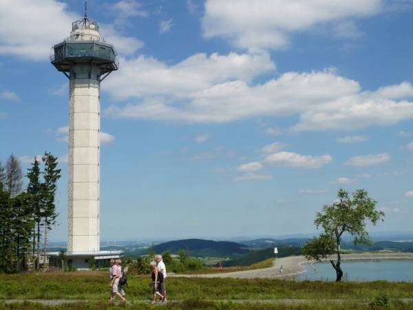
The walk starts at the Kuurpark to the valley station of the cable car with which we drive to the Ettelsberg (free with MeineCardPlus ) and enjoy the magnificent panorama of the Willingen basin. Sporty hikers can also walk uphill (+45 min.). From the Ettelsberg-top the trail is also suitable for buggies with good suspension. The Hochheide Tower is the highest viewpoint in the Sauerland and all Northwest Germany (875 meters above sea level). From here you have a magnificent view over the Sauerland, the mountains of the Sauerland. North Hesse - and with good visibility up to the Teutenburger Forest. Even the Harz / Brocken is rarely visible with binoculars in clear weather. Then the actual walk starts:
Option 1 leads along the back through the walking area Ettelsberg to the ski slopes Mühlenkopf: go right along the tower and the mountain lake towards Clemesberg/Hochheide Hoher Hagen; after about 400 meters you reach the Kyrillpfad (a lot of fun when climbing!). Then you continue to the "Großer Grube," a hiker's spot with a refuge. Here you turn left towards Mühlenkopfschans (marked). After about 1.5 km you reach the inrun-tower of the largest ski slope in the world. (For € 2 you can take the lift to the Adlerhorst to share the view of the staggering depths with the ski jumpers). Then you can test your nerves at dizzying height with a trip over the 669 meters long Skywalk.
Now there are two possibilities:
- either the 1 km shorter and more comfortable option by cable car (free with MeineCardPlus ) to the ski stadium and then to the Romantikhotel Stryckhaus.
- does not use the cable car but follows the forest path slightly downhill through the forest. After the strong turn to the right you go left into the forest nature path (not suitable for prams - or follow the forest path to the Romantikhotel Stryckhaus, where the path passes again through the forest path, the pram route is 300m shorter than the forest path). At the end of the forest nature trail you get to a forest path, where you turn sharply to the right and gently walk downhill towards the Romantikhotel Stryckhaus. (Distance from Ettelsberg 3.6 km via the forest nature path and 2.6 km by cable car)
Option 2 leads us around the Ettelsberg with a beautiful panorama of Willingen and the nature park Diemelsee.
You pass Siggis hut on the left and then you pass a path through the Hochheide. It leads you around the Ettelsberg along the forest path "Am Tiasbusch" along the new K1 chairlift route. On the way we enjoy a wonderful panorama all over Willingen and a great view of the nature park Diemelsee. The trail then leads us under the cable car to the upper Wilddieblift and along the nature and recreation park to the Romantikhotel-Stryckhaus. There is the possibility to go from the Stryckhaus 2x500m back to the Mühlenkopf ski slope and the Skywalk to run (see variant 1).
(Route variant 2 from Ettelsberg to Stryckhaus 2.5 km)
In the Romatik hotel-Stryckhaus both variants of Ettelsberg come together again. You can stop at the Stryckhaus, alternative refreshments are the "Café Aufwind" on the Mühlenkopfschans or the "Alte Forsthaus im Stryck" which you can reach by walking 300m further and continuing from the Romantikhotel StryckHaus. You reach the bridge over the Itterbach, where you will find the restaurant "Altes Forsthaus" and a children's playground. From here you follow the walk to Willingen along the Itterbach through the Stryck Valley and Stryck Park (with water-run basin), along the spa pavilion towards the railway viaduct, where the adventure golf course is (free with MeineCardPlus). Continue towards the center of the main shopping street of Willingen. Opposite Göbel's Landhotel we turn left into a narrow path into the Kuurpark, where our walk ends. For the finals there is also a Kneipp-bassin and you can visit the gallery of Upland artists in the spa pavilion. (Distance from Stryckhaus to Kurpark 3 km)
Enjoy exploring nature and tourist highlights around Willingen!
shows more
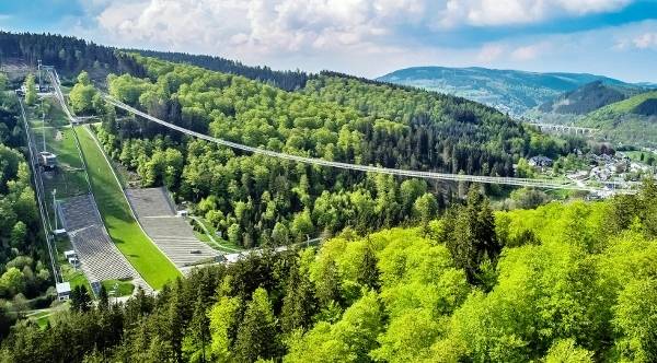
Skywalk Willingen - Germany's longest suspension bridge!
Best leisure and excursion sensation - opening July 2023! The Sauerland is one top attraction richer. The second longest free floating pedestrian suspension bridge in the world Tibetan style is located in Willingen since 2023 with a length of 669 meters and a height of 100 meters in the middle. Only the suspension bridge in the Giant Mountains in CZ is longer - which has the world record at 721 meters. Skywalk is located in the immediate vicinity of the Mühlenkopf-Skischans - the largest large hill in the world. In combination with the Mühlenkopf-Skischans and Germany's largest high-rise Neuer Hagen, as well as the Ettelsberg with cable car and Hochheide Tower - the highest viewpoint in Northwest Germany (875 m) - Willingen offers attractions and natural experiences with a top-regional character, making the already popular resort an absolute visitor for Sauerland holidaymakers and day trippers. Wherever in the Sauerland your holiday home is - a day of Willingen with its numerous super attractions is now on the program! More info and Online Tickets click HERE:Show more
Kahler Asten-Steig - dream hiking in the Sauerland
A treat for hikers!
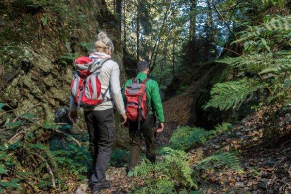
Whoever did it usually says that the Kahle Asten-Steig the most beautiful day walk of the Sauerland is. It is certified by the German hiking association as a premium hiking trail - and also as dream tour 2017.
Start and end of de 16 kilometer lange middelzware rondwandelroute is the park in Westfeld, one of the nine federal gold villages in Schmallenberger Sauerland. First, a narrow path goes uphill to the barbecue area and then continues over the valley hiking trail to Ohlenbach. Now the climb leads to the valley of the Schwarzen-Siepen, a nature reserve with the new climb bridge that spans a small biotope. Then the light goes uphill through a Kyrill area and a stalking path to the hunting huts.
An old canyon leads us straight up the mountain through a small gorge, along a small quarry, to the height of the walk, the Asten plateau with high heaths and a fantastic view over the land of 1000 mountains. Astenhaus is the ideal place to take a break before going downhill again along the Lenne source to young Lennetal.
Halfway the trail branches behind the ponds towards "Hoher Knochen." It passes through high spruce and beech forests to the top of the bone. Once upstairs we have another beautiful view over the vastness of the Schmallenberger Sauerland. From here it goes over a narrow path and a forest path downhill to the hotel "Hoher Knochen" with St. Elisbeth Kapel and Kneipp-bassin continue back towards Westfeld, where you can find a narrow root path along the cross-country skiing centre back to Westfelderpark, where you can enjoy your hiking day.
The Astensteig is a demanding hiking trail and requires a lot of endurance with its 570 altimeters. The lowest point is 493m, the highest point is 841m. Pure walking time approx. 5-6 hours.
Hiking map with height profile to download as pdf
shows more

Big Sauerland tour to Biggesee including Atta cave
Willingen - Winterberg - Schmallenberg - Lennetal - Attahöhle - Biggesee - Olpe - Eslohe - Hennesee/Meschede - Ruhrtal - Olsberg - Willingen You can also start this tour at a different location on the tour. This day tour is a wonderful Sauerland tour. Experience great views and many sights of the Sauerland during this tour. To have enough time to stop in between, you should gladly jump early out of bed! It starts from Willingen via Usseln and the Sauerland-Höhenstraat to Winterberg. Tussen Küstenlberg en Winterberg passeer je de RuhrbronFollow the B480 / B236 towards Schmallenberg. At the end of Winterberg is the ski resort with bobsleigh course, ski slopes and bike parkIf necessary, turn right and make a detour to the Kale Branches (Kahler Asten), where you can drive directly to the Astenhaus on top. Then it goes back to the B236/B480 on the Höhenstraße with a beautiful view. After the B480 splits to the left to Bad Berleburg (do not turn off), the B236 descends to the Schmallenberger Sauerland. Here you drive through the probably mooiste dorpjes van Sauerland - Obernkirchen, County and Schmallenberg. In Obernkirchen you turn left from the B236 towards Graftschaft and from there continue to the former Hanseatic city Schmallenberg, where you absolutely go through the Old Town Ring then it continues on the B236 through the Lennedal. Saalhausen stop for a 30 minute walk through the beautifully designed adventure park TalVital. We continue to Lennestadt. In OT-Grefenbrück the B55 direction Olpe and after about 500m on the roundabout take the first exit towards St. Klaas/Heppen. Hence via the L539 by the Biggedal to Attendorn. There is the Atta Cave - Germany's most beautiful drip rock cave. (94 km; pure travel time from Willingen to Attendorn on weekdays according to Google Maps 2,11 hours; however, on a relaxing sightseeing tour it takes about 3 hours; on a walk in Saalhausen 3.5 to 4 hours) Behind Attendorn it stretches. Biggesee reservoir extends to Olpe. From Olpe, you're driving back. on the B55 direction Lennestadt, then on the B55 by Elspe (Karl-May-Festival) via Eslohe with its beautiful spa parks and along the Hennesee to Meschede. Turn right there on the B7 through the Ruhr Valley to Bestwig, continue towards Brilon/Winterberg, after Nuttlar turn right onto the B480 to Olsberg, in the center turn right towards Willingen, past the Bruchhausen bricks to Brilon-Wald and then right onto the B251 to Willingen. (Pure driving time after 18.00 hours just under 2 hours). Tip for Eslohe: To the left of the main street is the Kaptain café/bakery, where you can probably get the best ice cream in the Sauerland. Lick your ice cream during a short walk through the spa gardens starting behind the café Google Maps route: outward journey to the Atta caveGoogle Maps route: back via Biggesee/Olpe
shows more

Tour nar het Märkisches Sauerland
Tourist attractions: Felsenmeer & Sauerlandpark Hemer, Hönnedal, Kasteel Altena, Lennedal, Sorpesee During the NRW summer holiday we recommend the tour on Wednesday to finish the day at Sorpeesee, because the Wednesdays event at the Sorroese is an afterwork party on the promenade in Langscheid with live music and colourful hustle and bustle. The tour starts at 9.30 a.m. in Wenneem/Freienohl on the A46, so that it can be mastered without stress. Guests staying in Willingen/Winterberg plan a 40-minute drive to the exit Wenneem (A46). If you come from Schmallenberg, you drive directly to Sundern-Amecke (approx. 40 minutes) via Eslohe and Grevenstein (brewery Veltins). From Wenneem drive through a beautiful valley and over the height at Hellefeld to Sundern and continue to Amecke to the Soropean (Freienohl-Amecke approx. 25 min.). Here is about 1 hour. Walk along the "Airlebnisweg," newly constructed in 2015, around the forewater of the So Europeane and in the evening we return to the So Europeane. Temporal note: Depending on your personal interests, you should choose your stops and activities. Highly recommended are Felsenmeer and Burg-Altena. Also the Louisenhütte in Balve (museum of early industrial ironworks) is highly recommended. Sauerlandpark and Wilde Wiese / Schombergturm can be skipped depending on your interests, possibly also the "Air life cycle" in Amecke (Save to 2.5 hours) The latter if you want to go to the afterwork party at Sorpeese on the eve. For more information click: QUANTITIES or SORPESEE RESERVOIR We continue to Balve, where we also have the Balver Cave pass (Europag's largest cultural and event cave), whose imposing cave-like entrance can be seen from the street. At the end of the village (right) is the lovely Louisenhütte (museum early industrial ironworks) in a beautiful side valley (+ plan 1 hour) in the immediate vicinity of Wocklum Castle with its riding stable, where the famous international horse riding event "Balve Optimum" takes place. year. Then we drive through the beautiful Hönnedal to Hemer (travel time approx. 30 minutes). Park at the Felsenmeer Stadium! You plan 2 hours to visit Felsenmeer & Sauerland-Park Hemer (only Felsenmeer 1 hour). Both facilities are located directly next to each other (SauerlandPark costs €5 entrance, children €2.50). Then we continue from Hemer to Altena Castle (about 30 min.) - one of the most beautiful castles in Germany. Plan at least 1 hour before the adventure lift and the castle in Altena. As an option you can take a break in one of the Lenne cafés, which are built as satellite bays along the Lenne. Unfortunately, the old town is rather boring because of the large number of empty shops to stroll through. From Altena the tour takes through the narrow Lennedal and on the Wild meadow with Schombergturm (one of the most beautiful views in the Sauerland +30 min.) Back to Sorpeese (approx. 1.10 a.m.) afterwork party at the Langscheid promenade along the lake (Live music from 19-22 hours) There are many nice restaurants along the promenade where you can close the day. From Langscheid back to Wenneem via Hüsten/A46 takes about 30 minutes (Willingen/Winterberg about 60 minutes). Tip: Outside the summer holidays and afterwork event, the route along the beautiful Sorpeese is still worthwhile (so not via Sundern to Wenneem in shortening). However, you can shorten from Altena via Neuenrade to Sorpeese and skip the Lennetal (time gain approx. 30 minutes). GoogleMaps route heenreis: Wennemen – Amecke/Sorpesee - Balve – Hemer – Altena GoogleMaps route terug: Altena – Langscheid/Sorpesee – Wennemenshows more

Ronde fietsticht Edersee (onze favorite fietstichtt)
The one who drove it says it was a dream tour! The varied route is partly about the Ederseebahn cycle path, by the beautiful natural Werbedal to the Edersee and over the Edersee Round Road. There is an extensive trip to/from Korbach (approx. 50km long), or a shortened alternative route to/from the pancake house in the Netze station (37km). The route is very suitable for Normal bicycles without significant slopes. Who does not take the train from Willingen, among others, but on arrival by car the tour can also start in Meineringhausen instead of Korbach. That saves about 10km. In Korbach is also an e-bike rental for those who want extra support for their own condition. During the bike ride you use the Edersee featherboat Scheid/Rehbach and the Waldecker cable car from the lake to the castle and the city. You can also pass by all attractions of the Edersee: summer toboggan run, swimming beach, wild park, TreeTopWald, klimbos, aqua park, dam, lake promenade in Waldeck and castle Waldeck. (All attractions, ferry and cable car free with MeineCardPlus) The tour starts in Korbach at the official beginning of the Ederseebahn cycle path in the Wildunger Landstrasse (500 m from the train station Korbach-Süd). Especially for the bike path there are also plenty of parking spaces. 200 m further there is a rental station for bicycles and e-bikes. It is advisable to reserve your bike there in advance! (www.funbikepark.de; Korbacher-EnergieZentrum GmbH & Co. KG, Wildunger Landstrasse 14 b, 34497 Korbach; Tel. 05631-5061876; E-mail: info@funbikepark.de) Those who come from Willingen can take the train to Korbach-Süd station without switching (free of charge with MeineCardPlus ). From there it is about 600m to the bicycle rental. (Walk down the path "Am Südbahnhof" to Heerstraße, then turn left and then turn left again. Then you are already on the Wildunger Landstraße. Go under the railway tunnel and at the roundabout straight ahead, you will find the bike rental on the right side ) Cycle route: We follow the Ederseebahn cycle path up to Meineringhausen (4.7km), where we leave the railway cycle path and Turn right towards Edersee. We drive into the village, cross the main road and always follow the sign with the bike path leading to the Edersee (11km). At the end of Meineringhausen the light rises to 500m, then it descends over fields the beautiful Werbedal towards Alraft, Ober-Werbe and beyond to Nieder-Werbe The route is usually a subtle slope. The trail is partly gravel, but easy to ride. Between Oberwerbe and Niederwerbe there is a picturesque area about 2 km long on a narrow forest path with trail character. Caution is advised in curves as cyclists can come to you. In Nieder-Werbe you reach a side branch of the Edersee. Here is the Summer toboggan run After the summer toboggan run you turn left onto the L3086 and turn right about 400 meters further to the Separation Peninsula (5 km). You have to drive about 1 km on the road, then a bike path starts along the road and later it runs into the forest. Here it is often a short time uphill and downhill. We reach Sepa with its many holiday homes and follow the local road until the end, where it leads to the large beach meadow with kiosk and the ferry goes. Here's the possibility to a bath break in the summer then cross over with the Edersee featherboat Scheid/Rehbach. (Featherboat hours 2019: 1 April to 3 October, Mon-Fr 11-17 hours (July-August 10-18 hours), Sat, Sun, Holidays and Long Weekends 10-18 hours Low season: April and October on weekends (Hessian Easter/Fire Holiday) and on sunny days, or by appointment: Tel. +49 1520-9721564. On the other side of the lake in Rehbach turn left onto the Strandweg. (Tip: In Rehbach there is a fishing stall with excellent fish sandwiches. After about 600m in front of the large parking lot turn left "Am Elschensberg" , after another 200m you drive straight ahead (please note: do not follow the paved road that bends slightly to the right) on a dam flanked with reeds . Then you come left on the charming gravel Edersee-Round path directly along the bosbank to the dam (about 5.5km). TreeTopWalk If you want to take with you, first drive about 500 meters to the right a little uphill on a bumpy gravel road and then back. Always along the southern bank of the forest you pass it klimbos and later it goes up a bit before the dam and we get out on a road. If you Wild game park If you want to take with you, turn right sharp and reach the wildlife park after about 900 meters. Others drive straight out of the street and reach it center of Edersee at the dam with numerous restaurants and the "Aqua park". That is not a pool, but a terrace super water playground for children. (For children it is essential to bring bathing clothes, clean clothes and a towel) In terms of design it represents the Ederdal. There are water wheels, mills, locks, waterfall ... so a great wet business. The best ice cream stand "Lecko mio" is also located on the gastro-mile in the west of the dam, with extravagant ice flavors that you should just try! You continue cycling over the legendary Dam wall and then 4 km left along the lake to Waldeck. At the intersection turn right onto the street to the town of Waldeck (170 altimeters, street very steep and unsuitable for cycling) and to the valley station of the Waldecker cable car, which also transports bicycles. Before you go up the mountain by cable car, you should at least take the 1 km long beautiful promenade along the lake Tip: We stretch our buttocks and legs here and walk a bit. Upon arrival at the mountain station you are on a small road dike - turn right to Waldeck Castle - and left turn it city centre in. In the center of Waldeck follow the main street to the left. Now you have to drive about 2.5 km over a pleasant, moderately driven country road towards Netze. It goes downhill constantly and you get speed. After a long bend to the right it is a little 100 meters light up - and then you turn right on the next dirt road. Now it goes downhill again. After about 300 meters of view of the village of Netze, turn left onto another field path and at the end of that field path turn right. Then it is about 500 meters to the Rich Road B485. Cross this diagonally to the right and you get to the pancake house in the old Netze stationFrom there you drive back to Korbach over the old railway line (18km). Whoever chose the short variant of 37km, is now at the start/finish. Because the forces are already decreasing, the Ederseebahn cycle path is ideal, because on the continuous asphalted railway cycle path There is only one. incline rate of max. 2%, which is also easy to drive without e-bike. Networks you can strengthen yourself even more in the recommended pancake house "Alter Bahnhof"On weekends when the weather is nice, it is often full - then you have to plan about 1 hour to stop for the delicious pancakes. This remark is important if you do not want to miss the train in Korbach! It takes about 1.5 hours from the pancake station to the end of the bike path, then you might have to turn in the rented bicycles and walk to the south station. Trains from Korbach-Süd back to Willingen every hour at 3:58 p.m. until late at 8:58 p.m. - Please note Sat/as late as 6:58 p.m. (from 03/2021) Impact: The Edersee bike tour is a fantastic, eventful day tour that you won't forget soon! However, it is impossible to visit all the facilities and you should think in advance about your individual highlights for which you would like time (e.g. Summer tobogganing, bathing break, TreeTopWalk, wild park, climbing, promenade walk, Waldeck Castle - please plan 1 hour for each attraction; summer toboggan run 30 min.). The pure cycling time of the whole trip is 4-5 hours for 60km, depending on the condition, because there are also stretches on the lake where you can't always drive fast. The ferry and cable car each take about 30-45 minutes, depending on the number of people. If you depend on the last train in Korbach, you must 2.5 hours in advance at the valley station The cable car is open until 18.00 hours. From the dam to the cable car (4km) you will need about 20 minutes cycling. Last update March 2021 (ramp times and train) - Information without guarantee! Route Willingen-Korbach (without roads) on Google Maps Route Korbach-Edersee-Korbach on Google Maps Short alternative route 37km from/to Pfannkuchenhaus in Netze on Google MapsShow more

Tip: MTB-tocht Hochheide - Bruchhausen-Stenen
One of the most beautiful mountain bike tours in the Sauerland leads through the nature of Willigen around the Ettelsberg. It is about 33 km long and runs along many tourist highlights, natural sights and amazing views. The tour is largely on dirt roads, partly along trails with trail character. In the beginning there is a continuous climb from about 2.5km from Stryck to Ettelsberg (230hm at 2.6km). An e-MTB is an advantage. The tour is also easy to drive with a trekking bike. If you want to avoid the first climb, you can also take the cable car to the Ettelsberg. In the further course the trails are relatively flat and the slopes are largely moderate - if it becomes crispy, only briefly (about 100m) - except for two longer passages with 10% slope for the Langenberg (60hm at 600m) and the place of execution (100hm at 1000m). Cycle route: The tour starts at the Ettelsberg cable car and first leads through the Stryck valley to the outlet of the Mühlenkopf-skischans. Then it goes back for a while and at Hotel Stryckhaus with an approximately 2 km long slope up to the Ettelsberg to the HochheideturmThe slope is usually moderate, but due to its length it requires a bit of stamina. Here is the first break in the Siggis hut. Now it goes along the Kyrill Path to the walking-rest area "Große Grube". From there along the Hoppecke Source to the New Hagen, Germany, a nature reserve of extraordinary beauty. At the top cross of the Clemensberg you have a great view of the Plateau of Winterberg. After about 600 meters you reach the Niedersfelder hut, where you can take a break. Then the trip leads to Langenberg (843m) - the highest summit of the Sauerland. For the Langenberg there is a about 600 meters long climb. From Langenberg you cycle about 600 meters back and then turn left towards Bruchhausen-Stene. The path is generally quite flat. Attention! The direct route to the Bruchhausen stones is deliberately not indicated, because the count wants to lead all visitors to the stones through the village of Bruchhausen, where there is an information centre with a cash register at the official driveway to the stones. The official route from Langenberg to the Bruchhausen stones is. about 7 km longer and you should descend the whole mountain and then go up again. It is therefore necessary to store the local Google Maps route description on your smartphone, because the internet is only partially available on the go (GPS is possible anywhere). It is easy to get lost without the clues, since none of the forest roads around the stones are indicated. Bruchhausen Stones after a short via ferrata you have at the highest stone - the Feldberg one adembenemend uitzicht over het HochsauerlandYou feel like you're in an eagle's nest. There's no gastronomy at the top of the stones. For a break, you have to bring snacks and drinks. Now it's back on the same forest path. to Willingen through the place of executionIf you turn left again on the tour, there is a longer steeper slope of about 1 km long. Without e-bike some people may lose their strength in an advanced stage. From the place of execution it is a flat slope along the ski slopes Sonnenlift and Ritzhagen and then to Willingen to the starting point of the tour. Attention! If you are not an experienced mountain biker with a technically good vehicle, do not choose the short path behind the place of execution, but drive on a sunny slope and hoppers! The short path is very steep and uneven.
Show more


